Datei:Isle of Man map-en.svg

Größe der PNG-Vorschau dieser SVG-Datei: 654 × 600 pixel. Ööder apliasangen: 262 × 240 pixel | 524 × 480 pixel | 838 × 768 pixel | 1.117 × 1.024 pixel | 2.234 × 2.048 pixel | 1.200 × 1.100 pixel.
Originaal datei (SVG-datei, grate: 1.200 × 1.100 pixel, dateigrate: 686 KB)

Beskriiwang
| Beskriiwang |
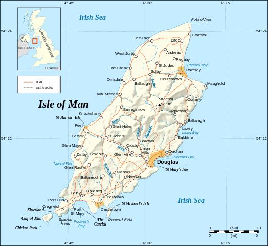
English: Map in English of the Isle of Man.
Note : The shaded relief is a raster image embedded in the SVG. Français : Carte en anglais de l'Île de Man. Note : Le relief ombré est une image bitmap incrustée dans le fichier SVG. UTM projection; WGS84 datum; shaded relief (composite image of N-W, W and N lightning positions); |
||
| Dootem | |||
| Kwel |
Own work ;
|
||
| Skriiwer of Konstler | Eric Gaba (Sting - fr:Sting) | ||
| Ferloof (Hü det datei brükt woort) |
|
||
| Ööder wersioonen |
[]
|


|
This SVG file contains embedded text that can be translated into your language, using any capable SVG editor, text editor or the SVG Translate tool. For more information see: About translating SVG files. |
Lisens
Ik hual a rochten üüb detdiar werk, an du det frei oner a lisensen:

|
Dü könst det datei kopiare, widjerdu of feranre efter a reegeln faan't GNU Free Documentation License, wersion 1.2 of leeder faan't Free Software Foundation; diar as niks ünferanerlik an nään tekst üüb a föör- of bääftsidj. Dü könst di lisens tekst efterlees bi GNU Free Documentation License. |
| Detdiar datei häält en lisens oner det Creative-Commons-lisens „Nööm nääm - Oner salew konditjuunen 3.0. Ei portiaret“. | ||
| ||
| Detdiar lisenstiaken kaam mä't GFDL lisens update. |
Diese Datei ist unter den Creative-Commons-Lizenzen „Namensnennung – Weitergabe unter gleichen Bedingungen 2.5 generisch“, „2.0 generisch“ und „1.0 generisch“ lizenziert.
- Dü mutst detdiar werk
- widjer du – detdiar werk kopiare an widjer du
- nei tuupstel – det werk feranre
- Oner jodiar konditjuunen:
- Nööm nääm – Dü skel di nööm faan di skriiwer of konstler nääm. Oober ei so, dat at so ütjsjocht, üs wan hi din werk gud fanjt.
- Oner josalew konditjuunen widjerdu – Wan dü detdiar werk feranerst, skel dü det resultaat oner detsalew lisens widjer du.
Schük di ian faan jodiar lisensen ütj.
Datei wersioonen
Klike üüb en tidjponkt, am detdiar wersion uuntulukin.
| Dootem/Tidj | Föörskaubil | Miaten | Brüker | Komentaar | |
|---|---|---|---|---|---|
| aktuel | 16:38, 4. Sep. 2008 | | 1.200 × 1.100 (686 KB) | Sting | New standard colors |
| 01:03, 22. Mei 2007 |  | 1.200 × 1.100 (786 KB) | Sting | {{Information |Description=Map in English of the Isle of Man |Source=Own work ;<br/>Background map and shaded relief : [http://www2.jpl.nasa.gov/srtm NASA Shuttle Radar Topography Mission] (SRTM3 v.2) (public domain) edited with [http: |
Hü det datei brükt woort
Detdiar sidj brükt detdiar datei:
Globaal brük faan datein
Jodiar ööder Wikis brük detdiar datei:
- Brük üüb ca.wikipedia.org
- Brük üüb cv.wikipedia.org
- Brük üüb cy.wikipedia.org
- Brük üüb de.wikipedia.org
- Brük üüb en.wikipedia.org
- Brük üüb en.wikibooks.org
- Brük üüb en.wikisource.org
- Brük üüb eo.wikipedia.org
- Brük üüb es.wikipedia.org
- Brük üüb es.wiktionary.org
- Brük üüb fa.wikipedia.org
- Brük üüb gag.wikipedia.org
- Brük üüb ga.wikipedia.org
- Brük üüb gv.wikipedia.org
- Brük üüb ha.wikipedia.org
- Brük üüb hr.wikipedia.org
- Brük üüb ja.wikipedia.org
- Brük üüb kw.wikipedia.org
- Brük üüb lt.wikipedia.org
- Brük üüb mi.wikipedia.org
- Brük üüb mr.wikipedia.org
- Brük üüb nl.wikipedia.org
- Brük üüb sk.wikipedia.org
- Brük üüb sl.wikipedia.org
- Brük üüb stq.wikipedia.org
- Brük üüb tr.wikipedia.org
- Brük üüb tr.wiktionary.org
- Brük üüb vi.wikipedia.org
- Brük üüb vls.wikipedia.org
- Brük üüb zh.wikipedia.org