Datei:South Africa Districts April 2006.png
Grate faan detdiar föörskaubil: 800 × 581 pixel. Ööder apliasangen: 320 × 232 pixel | 640 × 464 pixel | 1.024 × 743 pixel | 1.141 × 828 pixel.
Originaal datei (1.141 × 828 pixels, dateigrate: 38 KB, MIME-typ: image/png)

|
Dieses Bild des Typs Locator map sollte als Vektorgrafik im SVG-Format neu erstellt werden. Vektorformate haben zahlreiche Vorteile; weitere Information unter Commons:Media for cleanup. Wenn dir eine SVG-Version dieses Bildes vorliegt, so lade diese bitte hoch. Nach dem Hochladen der Datei ist diese Vorlage auf der aktuellen Bildbeschreibungsseite durch die Vorlage {{Vector version available}}, oder kürzer {{Vva}}, zu ersetzen. Es ist empfohlen die neue SVG-Datei „South Africa Districts April 2006.svg“ zu nennen – dann benötigt die Vorlage vector version available (bzw. vva) keinen Parameter.
|
Beskriiwang
| Beskriiwang |
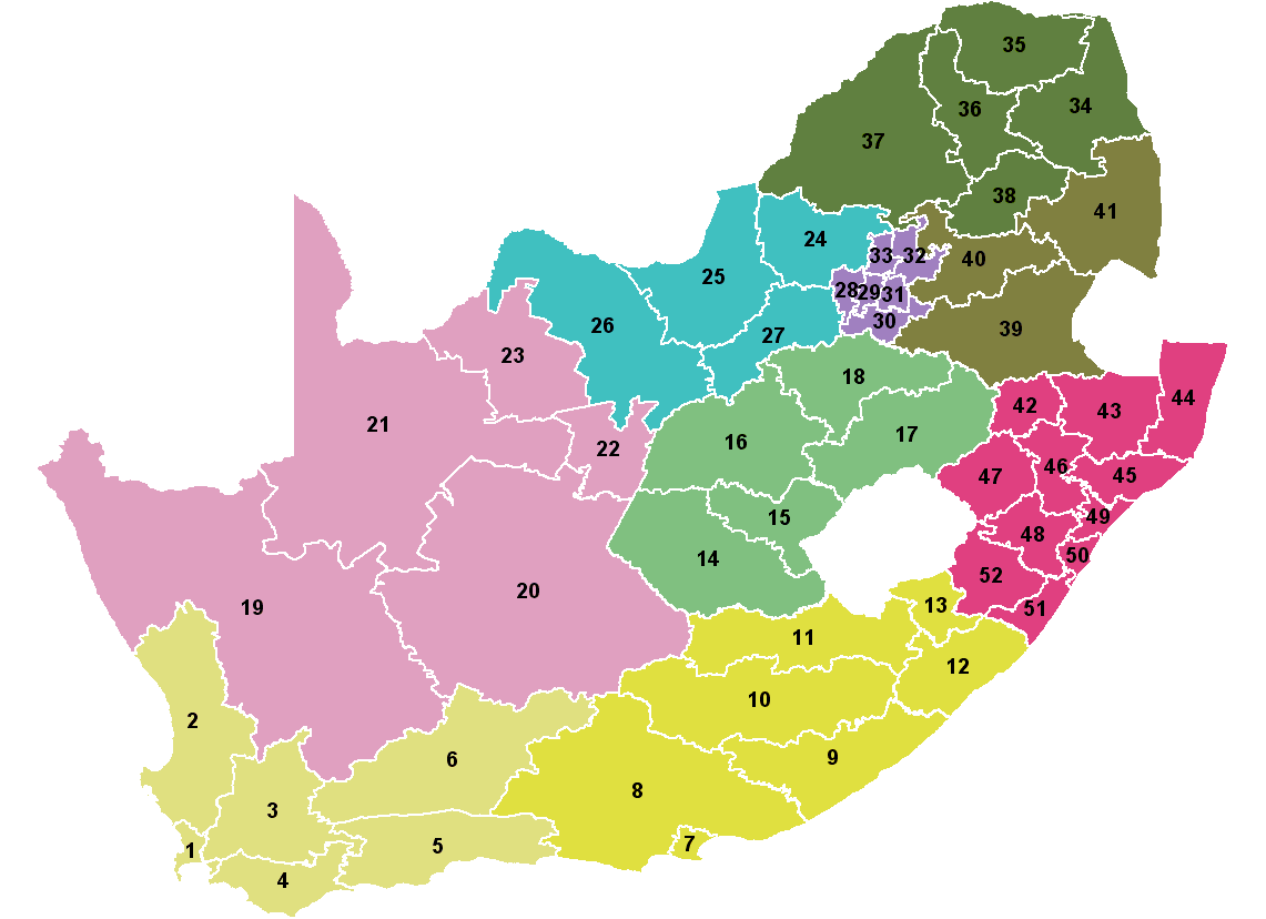
Map showing the 52 districts of South Africa. Colours indicate the 9 provinces. Created by Wayne Dam using data from the Municipal Demarcation Board after the 12th amendment to the Constitution. |
| Dootem | |
| Kwel | Created by me from Shapefile data from the Municipal Demarcation Board, South Africa. |
| Skriiwer of Konstler | Wayne Dam (User:Waynedam) |
| Ferloof (Hü det datei brükt woort) |
Dual-licensed under the GFDL and CC-By-SA-2.5, 2.0, and 1.0. |
Lisens
Ik hual a rochten üüb detdiar werk, an du det frei oner a lisensen:

|
Dü könst det datei kopiare, widjerdu of feranre efter a reegeln faan't GNU Free Documentation License, wersion 1.2 of leeder faan't Free Software Foundation; diar as niks ünferanerlik an nään tekst üüb a föör- of bääftsidj. Dü könst di lisens tekst efterlees bi GNU Free Documentation License. |
| Detdiar datei häält en lisens oner det Creative-Commons-lisens „Nööm nääm - Oner salew konditjuunen 3.0. Ei portiaret“. | ||
| ||
| Detdiar lisenstiaken kaam mä't GFDL lisens update. |
Diese Datei ist unter den Creative-Commons-Lizenzen „Namensnennung – Weitergabe unter gleichen Bedingungen 2.5 generisch“, „2.0 generisch“ und „1.0 generisch“ lizenziert.
- Dü mutst detdiar werk
- widjer du – detdiar werk kopiare an widjer du
- nei tuupstel – det werk feranre
- Oner jodiar konditjuunen:
- Nööm nääm – Dü skel di nööm faan di skriiwer of konstler nääm. Oober ei so, dat at so ütjsjocht, üs wan hi din werk gud fanjt.
- Oner josalew konditjuunen widjerdu – Wan dü detdiar werk feranerst, skel dü det resultaat oner detsalew lisens widjer du.
Schük di ian faan jodiar lisensen ütj.
Datei wersioonen
Klike üüb en tidjponkt, am detdiar wersion uuntulukin.
| Dootem/Tidj | Föörskaubil | Miaten | Brüker | Komentaar | |
|---|---|---|---|---|---|
| aktuel | 23:04, 15. Apr. 2006 | | 1.141 × 828 (38 KB) | Waynedam | Map showing the 52 districts of South Africa. Colours indicate the 9 provinces. Created by Wayne Dam using data from the Municipal Demarcation Board after the 12th amendment to the Constitution. |
Hü det datei brükt woort
Detdiar sidj brükt detdiar datei:
Globaal brük faan datein
Jodiar ööder Wikis brük detdiar datei:
- Brük üüb als.wikipedia.org
- Brük üüb bg.wikipedia.org
- Brük üüb ca.wikipedia.org
- Brük üüb dsb.wikipedia.org
- Brük üüb en.wikipedia.org
- Brük üüb eo.wikipedia.org
- Brük üüb fi.wikipedia.org
- Brük üüb gl.wikipedia.org
- Brük üüb hu.wikipedia.org
- Brük üüb id.wikipedia.org
- Brük üüb it.wikipedia.org
- Brük üüb ja.wikipedia.org
- Brük üüb lt.wikipedia.org
- Brük üüb mr.wikipedia.org
- Brük üüb nl.wikipedia.org
- Brük üüb nov.wikipedia.org
- Brük üüb pl.wikipedia.org
- Brük üüb pt.wikipedia.org
- Brük üüb rm.wikipedia.org
- Brük üüb ro.wikipedia.org
- Brük üüb sw.wikipedia.org
- Brük üüb tr.wikipedia.org