Datei:South America southern tip pol.png

Grate faan detdiar föörskaubil: 800 × 494 pixel. Ööder apliasangen: 320 × 198 pixel | 640 × 395 pixel | 1.024 × 632 pixel | 1.280 × 790 pixel | 2.560 × 1.581 pixel | 3.859 × 2.383 pixel.
Originaal datei (3.859 × 2.383 pixels, dateigrate: 596 KB, MIME-typ: image/png)
Beskriiwang
| Beskriiwang |
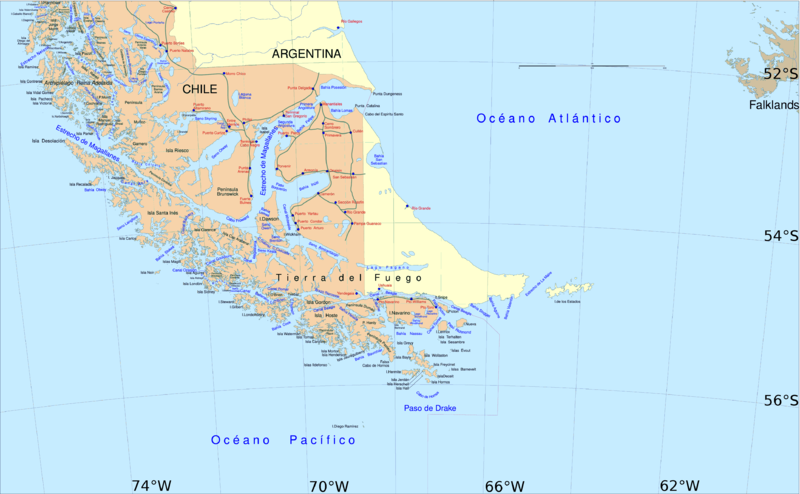
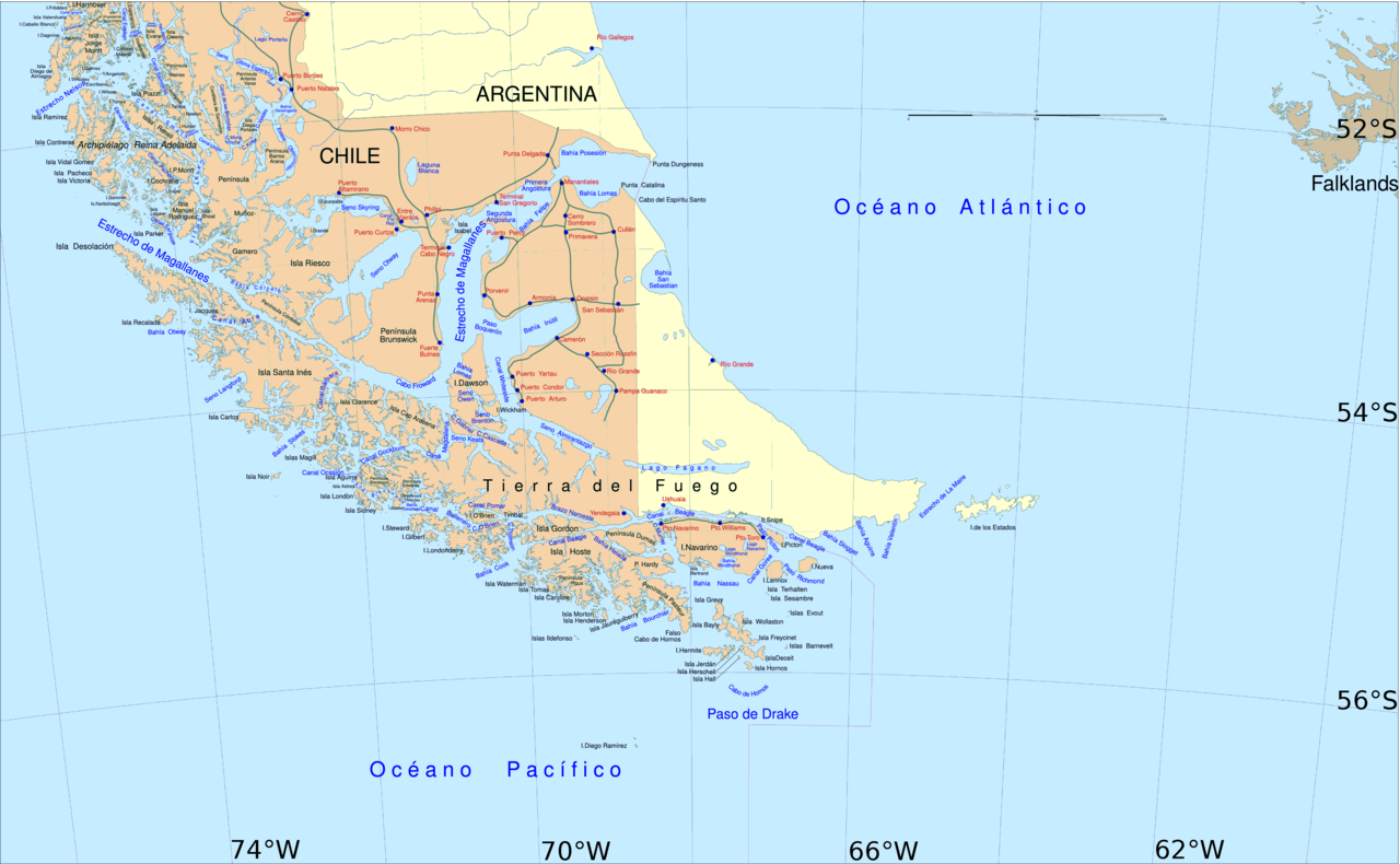
English: Political map of southern Chile and Argentina, from Straits of Magellan to Cape Horn.
Español: Mapa político del sur de Chile y la Argentina, entre el estrecho de Magallanes y el cabo de Hornos. |
||||
| Dootem | |||||
| Kwel | File:Sur2.gif | ||||
| Skriiwer of Konstler | User:Createaccount | ||||
| Ferloof (Hü det datei brükt woort) |
|
||||
| Ööder wersioonen | Derivative works of this file: Metula.svg |
Lisens

|
Dü könst det datei kopiare, widjerdu of feranre efter a reegeln faan't GNU Free Documentation License, wersion 1.2 of leeder faan't Free Software Foundation; diar as niks ünferanerlik an nään tekst üüb a föör- of bääftsidj. Dü könst di lisens tekst efterlees bi GNU Free Documentation License. |
| Detdiar datei häält en lisens oner det Creative-Commons-lisens „Nööm nääm - Oner salew konditjuunen 3.0. Ei portiaret“. | ||
| ||
| Detdiar lisenstiaken kaam mä't GFDL lisens update. |
Datei wersioonen
Klike üüb en tidjponkt, am detdiar wersion uuntulukin.
| Dootem/Tidj | Föörskaubil | Miaten | Brüker | Komentaar | |
|---|---|---|---|---|---|
| aktuel | 16:06, 30. Apr. 2016 | | 3.859 × 2.383 (596 KB) | Hohum | Cartographic colours |
| 13:09, 3. Apr. 2013 |  | 3.859 × 2.383 (597 KB) | Keysanger | Margin right and top cropped | |
| 12:47, 3. Apr. 2013 |  | 3.859 × 2.383 (597 KB) | Keysanger | "Estrecho Nelson" added Bigger Latitude and Longitude within the image empty margin cropped | |
| 21:30, 3. Mei 2009 |  | 3.894 × 2.441 (639 KB) | Pitichinaccio | different colour | |
| 21:29, 3. Mei 2009 |  | 3.894 × 2.441 (639 KB) | Pitichinaccio | {{Information |Description={{en|1=political map of southern Chile/Argentina: From Straits of Magellan to Cape Horn}} |Source=File:Sur2.gif |Author=User:Createaccount |Date=2008 |Permission={{GFDL-GMT}}} |other_versions=File:Sur2.gif }} <!-- |
Hü det datei brükt woort
Jodiar 2 sidjen brük detdiar datei:
Globaal brük faan datein
Jodiar ööder Wikis brük detdiar datei:
- Brük üüb af.wikipedia.org
- Brük üüb als.wikipedia.org
- Brük üüb ar.wikipedia.org
- Brük üüb ast.wikipedia.org
- Brük üüb br.wikipedia.org
- Brük üüb ca.wikipedia.org
- Brük üüb de.wikipedia.org
- Brük üüb de.wiktionary.org
- Brük üüb el.wikipedia.org
- Brük üüb en.wikipedia.org
- Cape Froward
- Porvenir, Chile
- Santa Inés Island
- Puerto Toro
- False Cape Horn
- Puerto del Hambre
- Maritime history of California
- Brunswick Peninsula
- Almirantazgo Fjord
- Fjord of the Mountains
- Primera Angostura
- Aracena Island
- Punta Dúngeness
- Muñoz Gamero Peninsula
- Seno Otway
- Mitre Peninsula
- Marlborough (1876 ship)
Muar globaal brük faan detdiar datei.