Datei:Çanakkale districts.png

Grate faan detdiar föörskaubil: 776 × 600 pixel. Ööder apliasangen: 311 × 240 pixel | 621 × 480 pixel | 994 × 768 pixel | 1.056 × 816 pixel.
Originaal datei (1.056 × 816 pixels, dateigrate: 43 KB, MIME-typ: image/png)
Beskriiwang
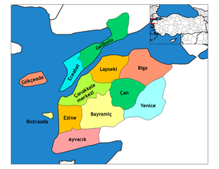
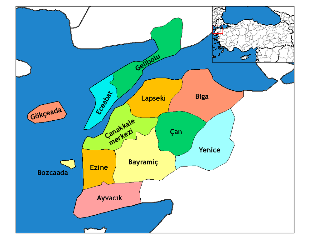
| Beskriiwang | Map of the districts of Canakkale province in Turkey. Created by Rarelibra 19:28, 1 December 2006 (UTC) for public domain use, using MapInfo Professional v8.5 and various mapping resources. Edited by One Homo Sapiens Corrected text where İ,Ş,ı,ğ,or ş occurs in name. Source: [statoids-com]. Increased font size and enhanced color differences among adjacent districts. |
| Dootem | 31. Marts 2007 (Original-Hochladedatum) |
| Kwel | Die Autorenschaft wurde nicht in einer maschinell lesbaren Form angegeben. Es wird angenommen, dass es sich um ein eigenes Werk handelt (basierend auf den Rechteinhaber-Angaben). |
| Skriiwer of Konstler | Die Autorenschaft wurde nicht in einer maschinell lesbaren Form angegeben. Es wird Denizz~commonswiki als Autor angenommen (basierend auf den Rechteinhaber-Angaben). |
Lisens
| Ik haa a rochten üüb detdiar datei an du det frei üs public domain (för arken frei). Det täält uun arke lun. Uun enkelt lunen mei det ei mögelk wees. Wan det so as: Arken koon detdiar werk brük för wat hi wal, wan det uun sin lun rochtelk mögelk as. |
Datei wersioonen
Klike üüb en tidjponkt, am detdiar wersion uuntulukin.
| Dootem/Tidj | Föörskaubil | Miaten | Brüker | Komentaar | |
|---|---|---|---|---|---|
| aktuel | 06:22, 29. Det. 2008 | | 1.056 × 816 (43 KB) | One Homo Sapiens | Corrected text where İ,Ş,ı,ğ,or ş occurs in name. Source: [statoids-com]. Increased font size and enhanced color differences among adjacent districts. |
| 17:47, 12. Apr. 2007 |  | 776 × 600 (110 KB) | KureCewlik81 | ||
| 09:01, 31. Mar. 2007 |  | 1.056 × 816 (33 KB) | Denizz~commonswiki | == Summary == Map of the districts of Canakkale province in Turkey. Created by Rarelibra 19:28, 1 December 2006 (UTC) for public domain use, using MapInfo Professional v8.5 and various mapping resources. == Licensing == {{PD-self}} <!- |
Hü det datei brükt woort
Detdiar sidj brükt detdiar datei:
Globaal brük faan datein
Jodiar ööder Wikis brük detdiar datei:
- Brük üüb ast.wikipedia.org
- Brük üüb azb.wikipedia.org
- Brük üüb ba.wikipedia.org
- Brük üüb bg.wikipedia.org
- Brük üüb ca.wikipedia.org
- Brük üüb ceb.wikipedia.org
- Brük üüb ce.wikipedia.org
- Brük üüb cs.wikipedia.org
- Brük üüb de.wikipedia.org
- Brük üüb diq.wikipedia.org
- Brük üüb el.wikipedia.org
- Brük üüb en.wikipedia.org
- Imbros
- Çanakkale Province
- User talk:Rarelibra/Maps4
- Gökçeada District
- List of populated places in Çanakkale Province
- Districts of Turkey
- Akbaş arms depot raid
- Bozcaada, Çanakkale
- Governor of Çanakkale
- Gelibolu District
- Ayvacık District, Çanakkale
- Bayramiç District
- Biga District
- Çan District
- Çanakkale District
- Eceabat District
- Ezine District
- Lapseki District
Muar globaal brük faan detdiar datei.