Datei:Adygea districts.png

Grate faan detdiar föörskaubil: 785 × 600 pixel. Ööder apliasangen: 314 × 240 pixel | 628 × 480 pixel | 1.013 × 774 pixel.
Originaal datei (1.013 × 774 pixels, dateigrate: 56 KB, MIME-typ: image/png)
Beskriiwang
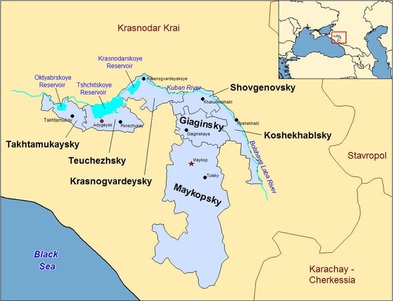
| Beskriiwang | Map of the districts of the Adygea republic of Russia. Created by Rarelibra 13:10, 30 March 2007 (UTC) for public domain use, using MapInfo Professional v8.5 and various mapping resources. |
| Dootem | 30. Marts 2007 (Original-Hochladedatum) |
| Kwel | Die Autorenschaft wurde nicht in einer maschinell lesbaren Form angegeben. Es wird angenommen, dass es sich um ein eigenes Werk handelt (basierend auf den Rechteinhaber-Angaben). |
| Skriiwer of Konstler | Die Autorenschaft wurde nicht in einer maschinell lesbaren Form angegeben. Es wird Rarelibra als Autor angenommen (basierend auf den Rechteinhaber-Angaben). |
Previous summary and history (en.wikipedia)
Map of the districts of the Republic of Adygea (federal subject of Russia). Created by Rarelibra 20:52, 20 December 2006 (UTC) for public domain use, using MapInfo Professional v8.5 and various mapping resources. Special thanks to w:User:Ezhiki for both his patience and input to help complete this map for his wiki project.
- 16:06, April 3, 2007 . . Rarelibra (Talk | contribs | block) . . 1056×816 (58,397 bytes) (Updated version)
- 17:35, March 27, 2007 . . Rarelibra (Talk | contribs | block) . . 823×752 (50,852 bytes) (Updated map)
- 22:34, December 20, 2006 . . Rarelibra (Talk | contribs | block) . . 1281×878 (48,913 bytes) (Map of the districts of the Republic of Adygea (a federal subject of Russia). Created by ~~~~ for public domain use with attribution under GNU. Created using MapInfo Professional v8.5 and various mapping resources. Special thanks to User:Ezhiki for hi)
- 20:52, December 20, 2006 . . Rarelibra (Talk | contribs | block) . . 1281×878 (43,557 bytes) (Map of the districts of the Republic of Adygea (federal subject of Russia). Created by ~~~~ for public domain use, using MapInfo Professional v8.5 and various mapping resources. Special thanks to User:Ezhiki for both his patience and input to help com)
Lisens
| Ik haa a rochten üüb detdiar datei an du det frei üs public domain (för arken frei). Det täält uun arke lun. Uun enkelt lunen mei det ei mögelk wees. Wan det so as: Arken koon detdiar werk brük för wat hi wal, wan det uun sin lun rochtelk mögelk as. |
Datei wersioonen
Klike üüb en tidjponkt, am detdiar wersion uuntulukin.
| Dootem/Tidj | Föörskaubil | Miaten | Brüker | Komentaar | |
|---|---|---|---|---|---|
| aktuel | 00:53, 1. Jan. 2024 | | 1.013 × 774 (56 KB) | User-duck | Cropped border using CropTool with lossless mode. |
| 15:18, 23. Apr. 2007 |  | 1.056 × 816 (57 KB) | Rarelibra | Reverted to earlier revision | |
| 17:54, 21. Apr. 2007 |  | 1.056 × 816 (46 KB) | David Kernow~commonswiki | ||
| 18:04, 3. Apr. 2007 |  | 1.056 × 816 (57 KB) | Rarelibra | Updated version | |
| 15:10, 30. Mar. 2007 |  | 823 × 752 (50 KB) | Rarelibra | Map of the districts of the Adygea republic of Russia. Created by ~~~~ for public domain use, using MapInfo Professional v8.5 and various mapping resources. |
Hü det datei brükt woort
Detdiar sidj brükt detdiar datei:
Globaal brük faan datein
Jodiar ööder Wikis brük detdiar datei:
- Brük üüb af.wikipedia.org
- Brük üüb azb.wikipedia.org
- Brük üüb ca.wikipedia.org
- Brük üüb cy.wikipedia.org
- Brük üüb de.wikipedia.org
- Brük üüb el.wikipedia.org
- Brük üüb en.wikipedia.org
- Brük üüb fa.wikipedia.org
- Brük üüb fi.wikipedia.org
- Brük üüb fr.wikipedia.org
- Brük üüb incubator.wikimedia.org
- Brük üüb io.wikipedia.org
- Brük üüb it.wikipedia.org
- Brük üüb krc.wikipedia.org
- Brük üüb lv.wikipedia.org
- Brük üüb mn.wikipedia.org
- Brük üüb nl.wikipedia.org
- Brük üüb pl.wikipedia.org
- Brük üüb pl.wiktionary.org
- Brük üüb pt.wikipedia.org
- Brük üüb ru.wikivoyage.org