Datei:Ducatus Sleswicum sive Iutia Australis -map of Johannes Blaeu.jpg

Grate faan detdiar föörskaubil: 401 × 599 pixel. Ööder apliasangen: 160 × 240 pixel | 321 × 480 pixel | 514 × 768 pixel | 685 × 1.024 pixel | 1.338 × 2.000 pixel.
Originaal datei (1.338 × 2.000 pixels, dateigrate: 1,13 MB, MIME-typ: image/jpeg)
Beskriiwang
| Tiitel |
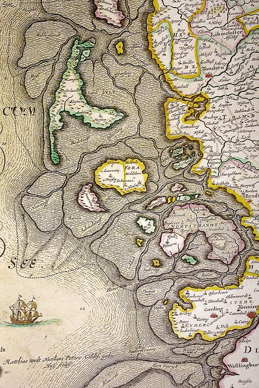
Latiinsk: Ducatus Sleswicum sive Iutia Australis Herzogtum Schleswig oder Süd-Jütland |
||||||||||||||||||||||||||||||||||||
| Dootem | |||||||||||||||||||||||||||||||||||||
| Kwel | Blaeu, Joan (1662) (Latiinsk) Atlas major, sive Cosmographia Blaviana, qua solum, salum, coelum, accuratissime describuntur, Amsterdam OCLC: 65862016. ; durch Southgeist, Deetsember 2006 | ||||||||||||||||||||||||||||||||||||
| Urheber |
|
||||||||||||||||||||||||||||||||||||
| Kartografische Angaben | |||||||||||||||||||||||||||||||||||||
| Abgebildetes Datum | |||||||||||||||||||||||||||||||||||||
| Ortsbezug | Nuurdfresklun | ||||||||||||||||||||||||||||||||||||
| Orientierung |
 |
||||||||||||||||||||||||||||||||||||
| Georeferenzierung | If inappropriate please set warp_status = skip to hide. | ||||||||||||||||||||||||||||||||||||
| Ööder wersioonen | |||||||||||||||||||||||||||||||||||||
.jpg)


Lisens
|
Dies ist eine originalgetreue fotografische Reproduktion eines zweidimensionalen Kunstwerks. Das Kunstwerk an sich ist aus dem folgenden Grund gemeinfrei:
Nach offizieller Ansicht der Wikimedia Foundation sind originalgetreue Reproduktionen zweidimensionaler gemeinfreier Werke gemeinfrei. Diese fotografische Reproduktion wird daher auch als gemeinfrei in den Vereinigten Staaten angesehen. Die Verwendung dieser Werke kann in anderen Rechtssystemen verboten oder nur eingeschränkt erlaubt sein. Zu Details siehe Reuse of PD-Art photographs.
| ||||
Datei wersioonen
Klike üüb en tidjponkt, am detdiar wersion uuntulukin.
| Dootem/Tidj | Föörskaubil | Miaten | Brüker | Komentaar | |
|---|---|---|---|---|---|
| aktuel | 23:18, 25. Det. 2006 | | 1.338 × 2.000 (1,13 MB) | Southgeist | Map of Nordfriesland map from Johannes Blaeu, showing the flooded isle of Nortstrandt. Map was published in 1662, but was a remake of a map published by Johannes Meyer and Caspar Danckwerth in 1652 Category:Kreis Nordfriesland, Germany [[Category:Hi |
Hü det datei brükt woort
Jodiar 4 sidjen brük detdiar datei:
Globaal brük faan datein
Jodiar ööder Wikis brük detdiar datei:
- Brük üüb da.wikipedia.org
- Brük üüb de.wikipedia.org
- Brük üüb es.wikipedia.org
- Brük üüb fy.wikipedia.org