Datei:Kayseri districts.png

Grate faan detdiar föörskaubil: 729 × 600 pixel. Ööder apliasangen: 292 × 240 pixel | 583 × 480 pixel | 999 × 822 pixel.
Originaal datei (999 × 822 pixels, dateigrate: 51 KB, MIME-typ: image/png)
Beskriiwang
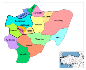
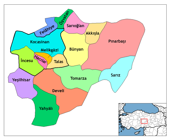
| Beskriiwang | Map of the districts of Kayseri province in Turkey. Created by Rarelibra 21:59, 1 December 2006 (UTC) for public domain use, using MapInfo Professional v8.5 and various mapping resources. Edited by One Homo Sapiens Corrected text where İ, Ş, ı, ğ, or ş occurs in name. Source: [statoids-com]. Increased font size and enhanced color differences among adjacent districts. User:Sae1962 Marked the boundaries of the provincial centre, the city of Kayseri, with bold lines. |
| Dootem | 1. Deetsember 2006 (Original-Hochladedatum) |
| Kwel | Die Autorenschaft wurde nicht in einer maschinell lesbaren Form angegeben. Es wird angenommen, dass es sich um ein eigenes Werk handelt (basierend auf den Rechteinhaber-Angaben). |
| Skriiwer of Konstler | Die Autorenschaft wurde nicht in einer maschinell lesbaren Form angegeben. Es wird Rarelibra als Autor angenommen (basierend auf den Rechteinhaber-Angaben). |
Lisens
| Ik haa a rochten üüb detdiar datei an du det frei üs public domain (för arken frei). Det täält uun arke lun. Uun enkelt lunen mei det ei mögelk wees. Wan det so as: Arken koon detdiar werk brük för wat hi wal, wan det uun sin lun rochtelk mögelk as. |
Datei wersioonen
Klike üüb en tidjponkt, am detdiar wersion uuntulukin.
| Dootem/Tidj | Föörskaubil | Miaten | Brüker | Komentaar | |
|---|---|---|---|---|---|
| aktuel | 13:25, 30. Jul. 2009 | | 999 × 822 (51 KB) | Sae1962 | {{Information |Description=Map of the districts of Kayseri province in Turkey. Created by Rarelibra 21:59, 1 December 2006 (UTC) for public domain use, using MapInfo Professional v8.5 and various mapping resources. Edited by [[User:One |
| 10:24, 4. Mei 2009 |  | 999 × 822 (50 KB) | Sae1962 | Added long vowels for better reading. | |
| 01:54, 29. Det. 2008 |  | 1.056 × 816 (35 KB) | One Homo Sapiens | Corrected text where İ,Ş,ı,ğ,or ş occurs in name. Source: [statoids-com]. Increased font size and enhanced color differences among adjacent districts. | |
| 23:59, 1. Det. 2006 |  | 1.056 × 816 (33 KB) | Rarelibra | Map of the districts of Kayseri province in Turkey. Created by ~~~~ for public domain use, using MapInfo Professional v8.5 and various mapping resources. |
Hü det datei brükt woort
Detdiar sidj brükt detdiar datei:
Globaal brük faan datein
Jodiar ööder Wikis brük detdiar datei:
- Brük üüb ast.wikipedia.org
- Brük üüb az.wikipedia.org
- Brük üüb be.wikipedia.org
- Brük üüb ca.wikipedia.org
- Brük üüb cs.wikipedia.org
- Brük üüb de.wikipedia.org
- Kayseri
- Talas (Kayseri)
- Yahyalı
- Hacılar (Kayseri)
- Talas (Bezirk)
- Tomarza
- Wikipedia:Kartenwerkstatt/Archiv/2011-01
- Wikipedia:Kartenwerkstatt/Archiv/2011-05
- Develi (Kayseri)
- Vorlage:Navigationsleiste Landkreise der Provinz Kayseri
- Akkışla
- Bünyan
- Felahiye
- İncesu (Kayseri)
- Kocasinan
- Melikgazi
- Özvatan
- Pınarbaşı (Kayseri)
- Sarıoğlan
- Sarız
- Yeşilhisar (Kayseri)
- Brük üüb diq.wikipedia.org
- Brük üüb en.wikipedia.org
Muar globaal brük faan detdiar datei.