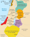
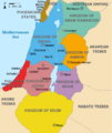
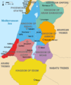
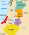
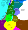
Datei:Kingdoms of Israel and Judah map 830.svg

Größe der PNG-Vorschau dieser SVG-Datei: 502 × 599 pixel. Ööder apliasangen: 201 × 240 pixel | 402 × 480 pixel | 644 × 768 pixel | 858 × 1.024 pixel | 1.717 × 2.048 pixel | 720 × 859 pixel.
Originaal datei (SVG-datei, grate: 720 × 859 pixel, dateigrate: 96 KB)
Datei wersioonen
Klike üüb en tidjponkt, am detdiar wersion uuntulukin.
| Dootem/Tidj | Föörskaubil | Miaten | Brüker | Komentaar | |
|---|---|---|---|---|---|
| aktuel | 16:12, 1. Okt. 2021 |  | 720 × 859 (96 KB) | Sadopaul | File uploaded using svgtranslate tool (https://svgtranslate.toolforge.org/). Added translation for ko. |
| 17:50, 10. Feb. 2017 |  | 720 × 859 (80 KB) | Malus Catulus | removed 'Sizu' - a weird artifact from the Norse original | |
| 01:48, 13. Feb. 2011 |  | 720 × 859 (78 KB) | Malus Catulus | - | |
| 13:29, 13. Jul. 2010 | 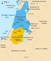 | 720 × 859 (79 KB) | Malus Catulus | Fixed Judah color | |
| 12:51, 13. Jul. 2010 |  | 720 × 859 (79 KB) | Malus Catulus | Added colors for the two kingdoms and converted their text to path and arial | |
| 01:53, 13. Jul. 2010 |  | 720 × 859 (62 KB) | Malus Catulus | Shrinked down the borders | |
| 21:43, 12. Jul. 2010 |  | 720 × 859 (62 KB) | Malus Catulus | {{Information |Description={{en|1=Map showing the ancient levant borders and ancient cities such as Urmomium and Jerash. The map also shows the region in the 9th century BCE. Notice the coastal land of Philistia, from which the name "Palestine |
Hü det datei brükt woort
Detdiar sidj brükt detdiar datei:
Globaal brük faan datein
Jodiar ööder Wikis brük detdiar datei:
- Brük üüb af.wikipedia.org
- Brük üüb als.wikipedia.org
- Brük üüb arz.wikipedia.org
- Brük üüb azb.wikipedia.org
- Brük üüb az.wikipedia.org
- Brük üüb be-tarask.wikipedia.org
- Brük üüb be.wikipedia.org
- Brük üüb bg.wikipedia.org
- Brük üüb bn.wikipedia.org
- Brük üüb br.wikipedia.org
- Brük üüb bs.wikipedia.org
- Brük üüb bxr.wikipedia.org
- Brük üüb ca.wikipedia.org
- Brük üüb cdo.wikipedia.org
- Brük üüb cs.wikipedia.org
- Brük üüb da.wikipedia.org
- Brük üüb de.wikipedia.org
- Brük üüb de.wikibooks.org
- Brük üüb en.wikipedia.org
Muar globaal brük faan detdiar datei.

