Datei:Lake Athabasca, Canada.jpg

Grate faan detdiar föörskaubil: 800 × 338 pixel. Ööder apliasangen: 320 × 135 pixel | 640 × 270 pixel | 1.156 × 488 pixel.
Originaal datei (1.156 × 488 pixels, dateigrate: 173 KB, MIME-typ: image/jpeg)
Beskriiwang
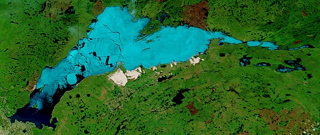
| Beskriiwang | Lake Athabasca, Canada. Lake Athabasca straddles the border between Alberta (west) and Saskatchewan (east) - the black line. In the false-color image, vegetation is green, water is dark blue, and ice (or snow) is light blue. |
| Dootem | Visualization Date: 2002-06-18 |
| Kwel | Visible Earth, NASA (extract) |
| Skriiwer of Konstler | Jacques Descloitres, MODIS Land Rapid Response Team, NASA/GSFC |
Cropped from the original 4800 x 3600 JPEG (4.4MB) image.
Lisens
| Diese Datei ist gemeinfrei (public domain), da sie von der NASA erstellt worden ist. Die NASA-Urheberrechtsrichtlinie besagt, dass „NASA-Material nicht durch Urheberrecht geschützt ist, wenn es nicht anders angegeben ist“. (NASA-Urheberrechtsrichtlinie-Seite oder JPL Image Use Policy). | ||
 |
Warnung:
|
Datei wersioonen
Klike üüb en tidjponkt, am detdiar wersion uuntulukin.
| Dootem/Tidj | Föörskaubil | Miaten | Brüker | Komentaar | |
|---|---|---|---|---|---|
| aktuel | 13:37, 18. Aug. 2006 | | 1.156 × 488 (173 KB) | Feydey | {{Information |Description= Lake Athabasca, Canada. Lake Athabasca straddles the border between Alberta (west) and Saskatchewan (east) - the black line. In the false-color image, vegetation is green, water is dark blue, and ice (or snow) is light blue. |S |
Hü det datei brükt woort
Detdiar sidj brükt detdiar datei:
Globaal brük faan datein
Jodiar ööder Wikis brük detdiar datei:
- Brük üüb af.wikipedia.org
- Brük üüb ar.wikipedia.org
- Brük üüb arz.wikipedia.org
- Brük üüb be.wikipedia.org
- Brük üüb bg.wikipedia.org
- Brük üüb bn.wikipedia.org
- Brük üüb bs.wikipedia.org
- Brük üüb ca.wikipedia.org
- Brük üüb ceb.wikipedia.org
- Brük üüb cv.wikipedia.org
- Brük üüb cy.wikipedia.org
- Brük üüb da.wikipedia.org
- Brük üüb el.wikipedia.org
- Brük üüb en.wikipedia.org
- Brük üüb eo.wikipedia.org
- Brük üüb es.wikipedia.org
- Brük üüb eu.wikipedia.org
- Brük üüb fa.wikipedia.org
- Brük üüb fr.wikipedia.org
- Brük üüb fy.wikipedia.org
- Brük üüb hu.wikipedia.org
- Brük üüb hy.wikipedia.org
- Brük üüb id.wikipedia.org
- Brük üüb incubator.wikimedia.org
- Brük üüb it.wikipedia.org
- Brük üüb ka.wikipedia.org
- Brük üüb kk.wikipedia.org
- Brük üüb ky.wikipedia.org
- Brük üüb lt.wikipedia.org
- Brük üüb lv.wikipedia.org
- Brük üüb nl.wikipedia.org
- Brük üüb no.wikipedia.org
- Brük üüb pl.wikipedia.org
- Brük üüb pl.wiktionary.org
- Brük üüb pnb.wikipedia.org
- Brük üüb pt.wikipedia.org
- Brük üüb ro.wikipedia.org
- Brük üüb ru.wikipedia.org
- Brük üüb sv.wikipedia.org
Muar globaal brük faan detdiar datei.