Datei:Liechtenstein topographic map-de Version Tschubby.png

Grate faan detdiar föörskaubil: 458 × 599 pixel. Ööder apliasangen: 183 × 240 pixel | 367 × 480 pixel | 587 × 768 pixel | 783 × 1.024 pixel | 2.189 × 2.862 pixel.
Originaal datei (2.189 × 2.862 pixels, dateigrate: 2,2 MB, MIME-typ: image/png)
Beskriiwang
| Beskriiwang |
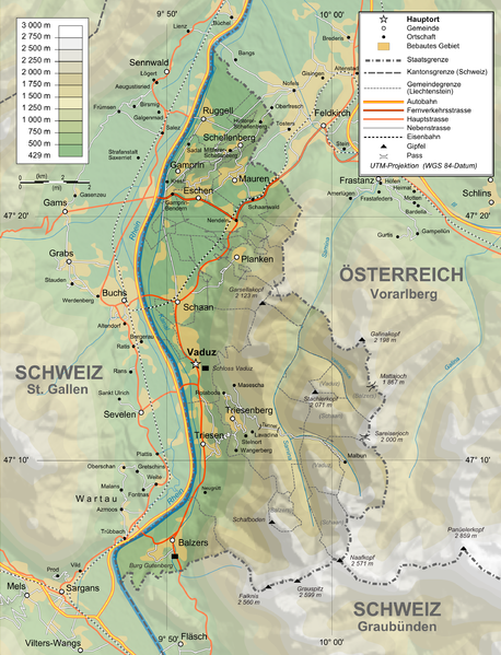
Deutsch: Topographische Karte von Liechtenstein, deutsche Version English: Topographic map in German of Liechtenstein Français : Carte topographique en allemand du Liechtenstein |
| Dootem | |
| Kwel |
English: Own work ; Topographic data from the NASA Shuttle Radar Topography Mission (SRTM3 v.2) (public domain) edited with 3DEM and dlgv32 Pro, and vectorized with Inkscape ; UTM projection ; WGS84 datum ; shaded relief (N-W lightning positions) edited with The Gimp ; Reference used for the additional data : * Rivers, cities, railroads, routes, bathymetry : Demis add-on for World Wind (see the approval e-mail and the Demis forum) ; * Borders and coast : World data bank II + + File:Liechtenstein-admin.png by user:Aotearoa ; Approximate scale of topographic data : 1:1,463,000 ; Note : The shaded relief is a raster image embedded in the SVG file. Français : Création personnelle ; Données topographiques de la NASA Shuttle Radar Topography Mission (SRTM3 v.2) (domaine public) éditées avec 3DEM etdlgv32 Pro, et vectorisées avec Inkscape ; projection UTM ; WGS84 datum ; relief ombré (éclairage du N-O) édité avec The Gimp ; Références utilisées pour les données complémentaires : * Rivières, villes, chemins de fers, routes, bathymétrie : Demis add-on for World Wind (cf. l'e-mail d'approbation de Demis et le Demis forum) ; * Frontières et côtes : World data bank II + File:Liechtenstein-admin.png de user:Aotearoa ; Échelle approximative des données topographiques : 1:1 463 000 ; Note : Le relief ombré est une image bitmap embarquée dans le fichier SVG. Approximate geographic limits of the map (30" close) : * SW corner : 47°02'05"N – 9°40'00"E * SE corner : 47°02'05"N – 9°70'00"E * NE corner : 47°27'55"N – 9°70'00"E * NW corner : 47°27'55"N – 9°40'00"E |
| Skriiwer of Konstler | Bourrichon, translated by NordNordWest, new Design by Tschubby |
| Ferloof (Hü det datei brükt woort) |
GFDL / Attribution and Share-Alike required |
| Ööder wersioonen |
|


Lisens
Ik hual a rochten üüb detdiar werk, an du det frei oner a lisensen:

|
Dü könst det datei kopiare, widjerdu of feranre efter a reegeln faan't GNU Free Documentation License, wersion 1.2 of leeder faan't Free Software Foundation; diar as niks ünferanerlik an nään tekst üüb a föör- of bääftsidj. Dü könst di lisens tekst efterlees bi GNU Free Documentation License. |
This file is licensed under the Creative Commons Attribution-Share Alike 4.0 International, 3.0 Unported, 2.5 Generic, 2.0 Generic and 1.0 Generic license.
- Dü mutst detdiar werk
- widjer du – detdiar werk kopiare an widjer du
- nei tuupstel – det werk feranre
- Oner jodiar konditjuunen:
- Nööm nääm – Dü skel di nööm faan di skriiwer of konstler nääm. Oober ei so, dat at so ütjsjocht, üs wan hi din werk gud fanjt.
- Oner josalew konditjuunen widjerdu – Wan dü detdiar werk feranerst, skel dü det resultaat oner detsalew lisens widjer du.
Schük di ian faan jodiar lisensen ütj.
Datei wersioonen
Klike üüb en tidjponkt, am detdiar wersion uuntulukin.
| Dootem/Tidj | Föörskaubil | Miaten | Brüker | Komentaar | |
|---|---|---|---|---|---|
| aktuel | 16:05, 3. Feb. 2016 | | 2.189 × 2.862 (2,2 MB) | RokerHRO | optipng -o7 -zm1-9 -i0 → 48.70% decrease |
| 13:37, 12. Feb. 2012 |  | 2.189 × 2.862 (4,3 MB) | Tschubby | {{Information |Description= |Source= |Date= |Author= |Permission= |other_versions= }} | |
| 13:31, 12. Feb. 2012 |  | 2.189 × 2.862 (8,6 MB) | Tschubby | {{Information |Description= |Source= |Date= |Author= |Permission= |other_versions= }} | |
| 18:17, 26. Jan. 2012 |  | 1.305 × 1.683 (2,3 MB) | Tschubby | {{Information |Description= |Source= |Date= |Author= |Permission= |other_versions= }} | |
| 18:13, 26. Jan. 2012 |  | 794 × 1.024 (1,26 MB) | Tschubby | {{Information |Description= |Source= |Date= |Author= |Permission= |other_versions= }} | |
| 11:05, 21. Jul. 2009 |  | 1.305 × 1.683 (1,46 MB) | Tschubby | {{Information |Description= |Source= |Date= |Author= |Permission= |other_versions= }} | |
| 10:50, 21. Jul. 2009 |  | 1.338 × 1.683 (1,48 MB) | Tschubby | == Summary == {{Information |Description={{de|Topographische Karte von Liechtenstein, deutsche Version}}{{en|Topographic map in German of Liechtenstein}}{{fr|Carte topographique en allemand du [[:fr:Liechtenstei |
Hü det datei brükt woort
Detdiar sidj brükt detdiar datei:
Globaal brük faan datein
Jodiar ööder Wikis brük detdiar datei:
- Brük üüb af.wikipedia.org
- Brük üüb als.wikipedia.org
- Brük üüb de.wikipedia.org
- Brük üüb es.wikipedia.org
- Brük üüb fo.wikipedia.org
- Brük üüb pdc.wikipedia.org
- Brük üüb pfl.wikipedia.org
- Brük üüb rm.wikipedia.org