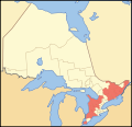
Datei:Map of Ontario COUNTIES.svg

Größe der PNG-Vorschau dieser SVG-Datei: 340 × 330 pixel. Ööder apliasangen: 247 × 240 pixel | 495 × 480 pixel | 791 × 768 pixel | 1.055 × 1.024 pixel | 2.110 × 2.048 pixel.
Originaal datei (SVG-datei, grate: 340 × 330 pixel, dateigrate: 84 KB)
Datei wersioonen
Klike üüb en tidjponkt, am detdiar wersion uuntulukin.
| Dootem/Tidj | Föörskaubil | Miaten | Brüker | Komentaar | |
|---|---|---|---|---|---|
| aktuel | 13:24, 12. Okt. 2007 |  | 340 × 330 (84 KB) | Vidioman | {{Created with Inkscape}} {{Information |Description=A map showing which census divisions of Ontario are counties |Source=Crop and trace of Image:Canada (geolocalisation).svg; trace of [http://en.wikipedia.org/wiki/Image:Ontario_subdivisions.PNG Imag |
Hü det datei brükt woort
Detdiar sidj brükt detdiar datei:
Globaal brük faan datein
Jodiar ööder Wikis brük detdiar datei:
- Brük üüb de.wikipedia.org
- Brük üüb en.wikipedia.org
- Brük üüb ru.wikipedia.org
- Brük üüb sv.wikipedia.org
- Brük üüb uk.wikipedia.org
- Brük üüb zh.wikipedia.org