Datei:Map of USA MD.svg

Größe der PNG-Vorschau dieser SVG-Datei: 286 × 186 pixel. Ööder apliasangen: 320 × 208 pixel | 640 × 416 pixel | 1.024 × 666 pixel | 1.280 × 832 pixel | 2.560 × 1.665 pixel.
Originaal datei (SVG-datei, grate: 286 × 186 pixel, dateigrate: 167 KB)
Clickable version
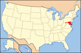
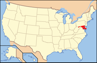
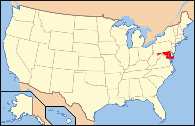
| Beskriiwang | Map of USA with Maryland highlighted | ||||||||
| Dootem | see file history below. | ||||||||
| Kwel | Aanj werk (Originaltext: own work by uploader, Eigenes Werk, basierend auf: Map of USA without state names.svg) | ||||||||
| Skriiwer of Konstler |
This version: uploader Base versions this one is derived from: originally created by Wapcaplet |
||||||||
| Ferloof (Hü det datei brükt woort) |
Diese Datei ist unter der Creative-Commons-Lizenz „Namensnennung 2.0 generisch“ (US-amerikanisch) lizenziert.
|
||||||||
| Ööder wersioonen | Map of USA with state names.svg | ||||||||
| SVG‑Erstellung |

Datei wersioonen
Klike üüb en tidjponkt, am detdiar wersion uuntulukin.
| Dootem/Tidj | Föörskaubil | Miaten | Brüker | Komentaar | |
|---|---|---|---|---|---|
| aktuel | 15:42, 1. Nof. 2012 | | 286 × 186 (167 KB) | Kmusser | remove VA portion of eastern shore |
| 11:06, 26. Apr. 2008 |  | 286 × 186 (167 KB) | Rub1615~commonswiki | Reverted to version as of 07:11, 9 June 2006 | |
| 17:32, 23. Apr. 2008 |  | 286 × 186 (183 KB) | Rfc1394 | Add an inset to the map enlarging the focus area to make it easier to see the designated state. | |
| 09:11, 9. Jun. 2006 |  | 286 × 186 (167 KB) | Huebi~commonswiki | {{Information| |Description=Map of USA with Maryland highlighted |other_versions=image:Map of USA with state names.svg }} Category:Maps of the United States Category:Maps of Maryland Category:SVG maps {{GFDL-en}}{{cc-by-2.0}}{{cc-by-sa- |
Hü det datei brükt woort
Detdiar sidj brükt detdiar datei:
Globaal brük faan datein
Jodiar ööder Wikis brük detdiar datei:
- Brük üüb af.wikipedia.org
- Brük üüb ang.wikipedia.org
- Brük üüb an.wikipedia.org
- Brük üüb arc.wikipedia.org
- Brük üüb ar.wikipedia.org
- Brük üüb arz.wikipedia.org
- Brük üüb ay.wikipedia.org
- Brük üüb az.wiktionary.org
- Brük üüb bg.wikipedia.org
- Brük üüb bi.wikipedia.org
- Brük üüb bo.wikipedia.org
- Brük üüb bpy.wikipedia.org
- Brük üüb bxr.wikipedia.org
- Brük üüb ca.wikipedia.org
- Brük üüb ce.wikipedia.org
- Brük üüb cs.wikipedia.org
- Brük üüb da.wikipedia.org
- Maryland
- Annapolis
- Baltimore
- Towson (Maryland)
- Worcester County (Maryland)
- Allegany County (Maryland)
- Anne Arundel County
- Denton (Maryland)
- Frederick (Maryland)
- Oakland (Maryland)
- Cumberland (Maryland)
- Sharpsburg (Maryland)
- Hagerstown (Maryland)
- La Plata (Maryland)
- Rockville (Maryland)
- Baltimore County
- Frederick County (Maryland)
Muar globaal brük faan detdiar datei.