Datei:Map of the North West with municipalities named and districts shaded (2016).svg

Größe der PNG-Vorschau dieser SVG-Datei: 800 × 553 pixel. Ööder apliasangen: 320 × 221 pixel | 640 × 442 pixel | 1.024 × 707 pixel | 1.280 × 884 pixel | 2.560 × 1.768 pixel | 912 × 630 pixel.
Originaal datei (SVG-datei, grate: 912 × 630 pixel, dateigrate: 598 KB)
.svg)
Beskriiwang
| Beskriiwang |
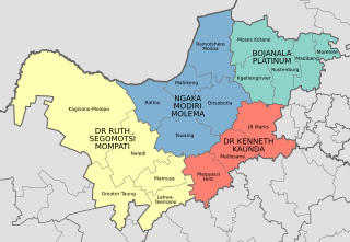
English: Map of the municipalities in the North West province of South Africa, with all municipalities named and district municipalities shaded different colours. |
| Dootem | |
| Kwel | Aanj werk; based on File:Map of the North West with municipalities blank (2016).svg |
| Skriiwer of Konstler | Htonl |
.svg)
Lisens
Ik hual a rochten üüb detdiar werk, an du det frei oner a lisensen:
Detdiar datei häält en lisens oner det Creative-Commons-lisens „Nööm nääm - Oner salew konditjuunen 3.0. Ei portiaret“.
- Dü mutst detdiar werk
- widjer du – detdiar werk kopiare an widjer du
- nei tuupstel – det werk feranre
- Oner jodiar konditjuunen:
- Nööm nääm – Dü skel di nööm faan di skriiwer of konstler nääm. Oober ei so, dat at so ütjsjocht, üs wan hi din werk gud fanjt.
- Oner josalew konditjuunen widjerdu – Wan dü detdiar werk feranerst, skel dü det resultaat oner detsalew lisens widjer du.

|
Dü könst det datei kopiare, widjerdu of feranre efter a reegeln faan't GNU Free Documentation License, wersion 1.2 of leeder faan't Free Software Foundation; diar as niks ünferanerlik an nään tekst üüb a föör- of bääftsidj. Dü könst di lisens tekst efterlees bi GNU Free Documentation License. |
Schük di ian faan jodiar lisensen ütj.
Datei wersioonen
Klike üüb en tidjponkt, am detdiar wersion uuntulukin.
| Dootem/Tidj | Föörskaubil | Miaten | Brüker | Komentaar | |
|---|---|---|---|---|---|
| aktuel | 17:24, 17. Nof. 2017 | | 912 × 630 (598 KB) | Htonl | Rename Venterdorp/Tlokwe to JB Marks |
| 23:07, 4. Feb. 2017 |  | 912 × 630 (603 KB) | Htonl | label placement tweak | |
| 23:05, 4. Feb. 2017 |  | 912 × 630 (603 KB) | Htonl | == {{int:filedesc}} == {{Information |Description ={{en|1=Map of the municipalities in the North West province of South Africa, with all municipalities named and district municipalities shaded different colours.}} |Source ={{own}}; based on... |
Hü det datei brükt woort
Detdiar sidj brükt detdiar datei:
Globaal brük faan datein
Jodiar ööder Wikis brük detdiar datei:
- Brük üüb en.wikipedia.org
- Brük üüb et.wikipedia.org
- Brük üüb pl.wikipedia.org
- Brük üüb zh.wikipedia.org
.svg)