Datei:Pyrenees topographic map-de.svg

Größe der PNG-Vorschau dieser SVG-Datei: 800 × 475 pixel. Ööder apliasangen: 320 × 190 pixel | 640 × 380 pixel | 1.024 × 608 pixel | 1.280 × 760 pixel | 2.560 × 1.520 pixel | 3.200 × 1.900 pixel.
Originaal datei (SVG-datei, grate: 3.200 × 1.900 pixel, dateigrate: 6,3 MB)
Beskriiwang
| Beskriiwang |
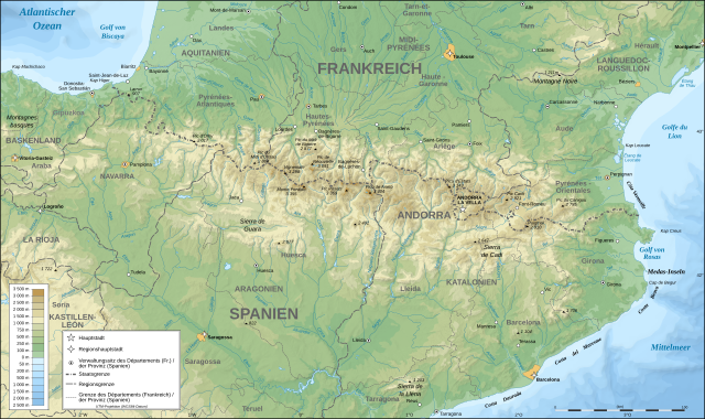
Deutsch: Topografische Karte der Pyrenäen in Deutsch.
English: Topographic map in German of the Pyrenees mountains.
Note: The shaded relief is a raster image embedded in the SVG file. Français : Carte topographique des Pyrénées en allemand.
Note : Le relief ombré est une image bitmap embarquée dans le fichier SVG. UTM projection; WGS84 datum; shaded relief (composite image of N-W, W and N lightning positions);
|
| Dootem | |
| Kwel |
Image:Pyrenees_topographic_map-fr.svg
Diese W3C-unbestimmte Vektorgrafik wurde mit Inkscape erstellt . |
| Skriiwer of Konstler | Eric Gaba (Sting - fr:Sting) |
| Ferloof (Hü det datei brükt woort) |
Attribution and Share-Alike required |
| Ööder wersioonen |
[]
|


|
This SVG file contains embedded text that can be translated into your language, using any capable SVG editor, text editor or the SVG Translate tool. For more information see: About translating SVG files. |
Lisens
Ik hual a rochten üüb detdiar werk, an du det frei oner a lisensen:

|
Dü könst det datei kopiare, widjerdu of feranre efter a reegeln faan't GNU Free Documentation License, wersion 1.2 of leeder faan't Free Software Foundation; diar as niks ünferanerlik an nään tekst üüb a föör- of bääftsidj. Dü könst di lisens tekst efterlees bi GNU Free Documentation License. |
| Detdiar datei häält en lisens oner det Creative-Commons-lisens „Nööm nääm - Oner salew konditjuunen 3.0. Ei portiaret“. | ||
| ||
| Detdiar lisenstiaken kaam mä't GFDL lisens update. |
Diese Datei ist unter den Creative-Commons-Lizenzen „Namensnennung – Weitergabe unter gleichen Bedingungen 2.5 generisch“, „2.0 generisch“ und „1.0 generisch“ lizenziert.
- Dü mutst detdiar werk
- widjer du – detdiar werk kopiare an widjer du
- nei tuupstel – det werk feranre
- Oner jodiar konditjuunen:
- Nööm nääm – Dü skel di nööm faan di skriiwer of konstler nääm. Oober ei so, dat at so ütjsjocht, üs wan hi din werk gud fanjt.
- Oner josalew konditjuunen widjerdu – Wan dü detdiar werk feranerst, skel dü det resultaat oner detsalew lisens widjer du.
Schük di ian faan jodiar lisensen ütj.
Datei wersioonen
Klike üüb en tidjponkt, am detdiar wersion uuntulukin.
| Dootem/Tidj | Föörskaubil | Miaten | Brüker | Komentaar | |
|---|---|---|---|---|---|
| aktuel | 20:31, 23. Sep. 2008 | | 3.200 × 1.900 (6,3 MB) | Sting | Using ETOPO1 data for bathymetry; new standard colors |
| 03:30, 5. Aug. 2007 |  | 3.200 × 1.900 (5,9 MB) | J. Schwerdtfeger~commonswiki | == Summary == {{Information |Description= {{de|Topografische Karte der Pyrenäen in Deutsch.}} {{en|Topographic map in German of the Pyrenees mountains.}} {{fr|Carte topographique des Pyrénées en all |
Hü det datei brükt woort
Detdiar sidj brükt detdiar datei:
Globaal brük faan datein
Jodiar ööder Wikis brük detdiar datei:
- Brük üüb als.wikipedia.org
- Brük üüb de.wikipedia.org
- Brük üüb mn.wikipedia.org