Originaal datei(1.016 × 1.222 pixels, dateigrate: 101 KB, MIME-typ: image/jpeg)

Detheer bil as faan Wikimedia Commons an koon faan ööder projekten brükt wurd. Det beskriiwang faan't beskriiwangssidj woort oner uunwiset.

Warning sign Dieses Bild muss aus folgendem Grund aktualisiert werden: The earlier forms of this map did not extend a dotted-line around Dongyin, Lienchiang (Tungyin). The northern edge of this map ought to be moved up a little bit (in latitude) so that a dotted line encompassing Dongyin (Tungyin) can be clearly drawn and so that we can see a few of the islands north of Lienchiang County in Haidao Township, PRC. Example of a better map from The Economist: [1]. Du könntest zusätzlich auch einen Zeitstempel auf das Bild setzen.
Bitte benachrichtige den Hochlader mit {{subst:update-note|1=File:Taiwan relief location map.jpg|2=The earlier forms of this map did not extend a dotted-line around Dongyin, Lienchiang (Tungyin). The northern edge of this map ought to be moved up a little bit (in latitude) so that a dotted line encompassing Dongyin (Tungyin) can be clearly drawn and so that we can see a few of the islands north of Lienchiang County in Haidao Township, PRC. Example of a better map from The Economist: [2].}} ~~~~

Beskriiwang

Beskriiwang
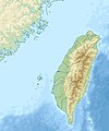
English: Relief location map of Taiwan.
  • Projection: Equirectangular projection, strechted by 110.0%.
  • Geographic limits of the map:
  • N: 26.4° N
  • S: 21.7° N
  • W: 118.0° E
  • E: 122.3° E
  • GMT projection: -JX17.204266666666665cd/20.68512992248063cd
  • GMT region: -R118.0/21.7/122.3/26.4r
  • GMT region for grdcut: -R118.0/21.7/122.3/26.4r
  • Relief: SRTM30plus.
  • Made with Natural Earth. Free vector and raster map data @ naturalearthdata.com.
Dootem
Kwel Aanj werk
Skriiwer of Konstler Uwe Dedering

Lisens

Ik hual a rochten üüb detdiar werk, an du det frei oner a lisensen:
w:de:Creative Commons
Nööm nääm Oner josalew konditjuunen widjerdu
Diese Datei ist unter den Creative-Commons-Lizenzen „Namensnennung – Weitergabe unter gleichen Bedingungen 3.0 nicht portiert“, „2.5 generisch“, „2.0 generisch“ und „1.0 generisch“ lizenziert.
Dü mutst detdiar werk
  • widjer du – detdiar werk kopiare an widjer du
  • nei tuupstel – det werk feranre
Oner jodiar konditjuunen:
  • Nööm nääm – Dü skel di nööm faan di skriiwer of konstler nääm. Oober ei so, dat at so ütjsjocht, üs wan hi din werk gud fanjt.
  • Oner josalew konditjuunen widjerdu – Wan dü detdiar werk feranerst, skel dü det resultaat oner detsalew lisens widjer du.
GNU head Dü könst det datei kopiare, widjerdu of feranre efter a reegeln faan't GNU Free Documentation License, wersion 1.2 of leeder faan't Free Software Foundation; diar as niks ünferanerlik an nään tekst üüb a föör- of bääftsidj. Dü könst di lisens tekst efterlees bi GNU Free Documentation License.
Schük di ian faan jodiar lisensen ütj.

Kurzbeschreibungen

Ergänze eine einzeilige Erklärung, was diese Datei darstellt.

In dieser Datei abgebildete Objekte

motiif

Urheber Tjiisk

Einige Werte ohne einen Wikidata-Eintrag

28. Deetsember 2010

MIME-Typ Tjiisk

image/jpeg

Datei wersioonen

Klike üüb en tidjponkt, am detdiar wersion uuntulukin.

Dootem/TidjFöörskaubilMiatenBrükerKomentaar
aktuel16:01, 19. Sep. 2019Föörskau för det wersion faan 16:01, 19. Sep. 20191.016 × 1.222 (101 KB)Geographyinitiativetemporary fix: extending the boundary out around Dongyin Township (as in China Fujian2 location map.svg and as in File:Nationalist China - administrative divisons. LOC 2007633622.jpg)
19:09, 3. Aug. 2019Föörskau för det wersion faan 19:09, 3. Aug. 20191.016 × 1.222 (537 KB)NordNordWestborder corrections
03:51, 3. Aug. 2019Föörskau för det wersion faan 03:51, 3. Aug. 20191.016 × 1.222 (96 KB)GeographyinitiativeProposed removal of three dashes (markers of the approximate PRC/ROC maritime boundary) which seemed to put Dadan Island, Erdan Island and Binlang Islet (檳榔嶼) outside the territory of Kinmen County, Taiwan/ROC. This is not the optimal form of the map, but is merely a quick removal of incorrect information. In the optimal situation, the line needs to be redrawn in the correct location, but I don't have the technical skill to produce such a map. (Basis: [http://ws.mac.gov.tw/001/Upload/OldFile/...
02:30, 3. Aug. 2019Föörskau för det wersion faan 02:30, 3. Aug. 20191.016 × 1.222 (96 KB)GeographyinitiativeProposed removal of two dashes (markers of the approximate PRC/ROC maritime boundary) which seemed to put {{w|Dadan Island}} and {{w|Erdan Island}} outside the territory of {{w|Kinmen County}}, Taiwan/ROC.
19:22, 28. Det. 2010Föörskau för det wersion faan 19:22, 28. Det. 20101.016 × 1.222 (452 KB)Uwe Dedering{{Information |Description={{en|1=Relief location map of Taiwan. * Projection: Equirectangular projection, strechted by 110.0%. * Geographic limits of the map: :* N: 26.4° N :* S: 21.7° N :* W: 118.0° E :* E: 122.3° E * GMT projection: -JX17.204266666

Jodiar 3 sidjen brük detdiar datei:

Globaal brük faan datein

Jodiar ööder Wikis brük detdiar datei:

Muar globaal brük faan detdiar datei.

Metadooten