Originaal datei (SVG-datei, grate: 1.425 × 1.212 pixel, dateigrate: 1,25 MB)
Detheer bil as faan Wikimedia Commons an koon faan ööder projekten brükt wurd.
Det beskriiwang faan't beskriiwangssidj woort oner uunwiset.
Beskriiwang
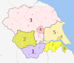
Map
Ceremonial county
County / unitary
Districts
1. South Yorkshire *
a ) Sheffield , b ) Rotherham , c ) Barnsley , d ) Doncaster
2. West Yorkshire *
a ) Wakefield , b ) Kirklees , c ) Calderdale , d ) Bradford , e ) Leeds
North Yorkshire (part only) 3. North Yorkshire †
a ) Selby , b ) Harrogate , c ) Craven , d ) Richmondshire , e ) Hambleton , f ) Ryedale , g ) Scarborough
4. York U.A.
East Riding of Yorkshire 5. East Riding of Yorkshire U.A.
6. Kingston upon Hull U.A.
Lincolnshire (part only) 7. North Lincolnshire U.A.
8. North East Lincolnshire U.A.
Key: †shire county | *metropolitan county
Lisens nööm nääm: Dr Greg and Nilfanion. Contains Ordnance Survey data © Crown copyright and database right 2011
Dü mutst detdiar werk
widjer du – detdiar werk kopiare an widjer dunei tuupstel – det werk feranre
Oner jodiar konditjuunen:
Nööm nääm – Dü skel di nööm faan di skriiwer of konstler nääm. Oober ei so, dat at so ütjsjocht, üs wan hi din werk gud fanjt.Oner josalew konditjuunen widjerdu – Wan dü detdiar werk feranerst, skel dü det resultaat oner detsalew lisens widjer du. https://creativecommons.org/licenses/by-sa/3.0 CC BY-SA 3.0 Creative Commons Attribution-Share Alike 3.0 true true Originaal datei-logbuk This image is a derivative work of the following images:
File:Yorkshire_and_the_Humber_districts_2011_map.svg licensed with Cc-by-sa-3.0, GFDL
2011-05-01T19:07:00Z Nilfanion 1425x1212 (1275424 Bytes) == Summary == {{Information |Description=Map of the [[w:Yorkshire and the Humber|Yorkshire and the Humber]] region showing the administrative districts. Equirectangular map projection on WGS 84 datum, with N/S stretched 170% File:English_ceremonial_counties_2010.svg licensed with Cc-by-sa-3.0, GFDL
2010-11-23T16:39:55Z Nilfanion 1108x1345 (308868 Bytes) thicker lines
2010-11-23T16:20:19Z Nilfanion 1108x1345 (301520 Bytes) tweaks
2010-10-26T20:34:20Z Nilfanion 817x990 (1391832 Bytes) {{Information |Description=Map showing the [[w:ceremonial counties of England]] including the City of London, in 2010. Equirectangular map projection on WGS 84 datum, with N/S stretched 170% Geographic limits: *West: 6.75W Hochgeladen mit derivativeFX
Nordfriisk Ergänze eine einzeilige Erklärung, was diese Datei darstellt.
Datei wersioonen
Klike üüb en tidjponkt, am detdiar wersion uuntulukin.
Dootem/Tidj Föörskaubil Miaten Brüker Komentaar aktuel 23:38, 2. Mei 2012 1.425 × 1.212 (1,25 MB) Dr Greg == {{int:filedesc}} == {{Information |Description={{en|Map of the Yorkshire and the Humber region of England, showing its counties and administrative districts. The county colours are the same as those in [[:File:English ...
Hü det datei brükt woort
Detdiar sidj brükt detdiar datei:
Globaal brük faan datein
Jodiar ööder Wikis brük detdiar datei:
Brük üüb ar.wikipedia.org
Brük üüb bn.wikipedia.org
Brük üüb en.wikipedia.org
Brük üüb fa.wikipedia.org
Brük üüb fr.wikipedia.org
Brük üüb hr.wikipedia.org
Brük üüb hu.wikipedia.org
Brük üüb mr.wikipedia.org
Brük üüb mzn.wikipedia.org
Brük üüb pl.wikipedia.org
Brük üüb pnb.wikipedia.org
Brük üüb pt.wikipedia.org
Brük üüb th.wikipedia.org
Brük üüb ur.wikipedia.org
Brük üüb vi.wikipedia.org
Brük üüb vls.wikipedia.org
Brük üüb zh-yue.wikipedia.org


