Datei:DominanzSchartenhoeheNew.png

Grate faan detdiar föörskaubil: 487 × 600 pixel. Ööder apliasangen: 195 × 240 pixel | 390 × 480 pixel | 624 × 768 pixel | 831 × 1.024 pixel | 1.736 × 2.138 pixel.
Originaal datei (1.736 × 2.138 pixels, dateigrate: 915 KB, MIME-typ: image/png)

|
Dieses Bild des Typs Graph sollte als Vektorgrafik im SVG-Format neu erstellt werden. Vektorformate haben zahlreiche Vorteile; weitere Information unter Commons:Media for cleanup. Wenn dir eine SVG-Version dieses Bildes vorliegt, so lade diese bitte hoch. Nach dem Hochladen der Datei ist diese Vorlage auf der aktuellen Bildbeschreibungsseite durch die Vorlage {{Vector version available}}, oder kürzer {{Vva}}, zu ersetzen. Es ist empfohlen die neue SVG-Datei „DominanzSchartenhoeheNew.svg“ zu nennen – dann benötigt die Vorlage vector version available (bzw. vva) keinen Parameter.
|
Beskriiwang
| Beskriiwang |
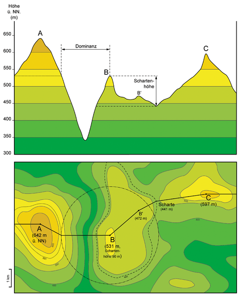
English: Top figure: Projection of terrain elevation along solid black line in the lower figure. Criteria for topographic isolation (Dominanz) and prominence (Schartenhöhe) are given for summit “B”.
Bottom figure: Corresponding topographic map. Dashed black line corresponds to the lowest contour line encircling summit “B” but no higher summit. Black dash-dot line delineates circular area of topographic isolation of summit “B”. Dotted black line corresponds to the contour line on summit “A” which is tangent to the “isolation circle” of summit “B”. Deutsch: Oben: Projektion der Topographie entlang der durchgezogenen schwarzen Linie in der unteren Abbildung. Eingezeichnet sind Dominanz und Schartenhöhe für Berg „B“. Unten: Entsprechende topographische Karte. Die gestrichelte schwarze Linie entspricht der niedrigsten Höhenlinie, die Berg „B“ einschließt aber keinen höheren Gipfel. Die schwarze Strichpunktlinie umreißt die Kreisfläche, die durch die Dominanz von Berg „B“ definiert ist. Die gepunktete schwarze Linie entspricht der Höhenlinie auf den Flanken von Berg „A“, die den „Dominanzkreis“ von Berg „B“ tangiert. |
| Dootem | |
| Kwel | Aanj werk : fiktional example with the known definitions of the subject implemented |
| Skriiwer of Konstler | Gretarsson |
Lisens
Ik hual a rochten üüb detdiar werk, an du det frei oner a lisensen:

|
Dü könst det datei kopiare, widjerdu of feranre efter a reegeln faan't GNU Free Documentation License, wersion 1.2 of leeder faan't Free Software Foundation; diar as niks ünferanerlik an nään tekst üüb a föör- of bääftsidj. Dü könst di lisens tekst efterlees bi GNU Free Documentation License. |
Diese Datei ist unter den Creative-Commons-Lizenzen „Namensnennung – Weitergabe unter gleichen Bedingungen 3.0 nicht portiert“, „2.5 generisch“, „2.0 generisch“ und „1.0 generisch“ lizenziert.
- Dü mutst detdiar werk
- widjer du – detdiar werk kopiare an widjer du
- nei tuupstel – det werk feranre
- Oner jodiar konditjuunen:
- Nööm nääm – Dü skel di nööm faan di skriiwer of konstler nääm. Oober ei so, dat at so ütjsjocht, üs wan hi din werk gud fanjt.
- Oner josalew konditjuunen widjerdu – Wan dü detdiar werk feranerst, skel dü det resultaat oner detsalew lisens widjer du.
Schük di ian faan jodiar lisensen ütj.
Datei wersioonen
Klike üüb en tidjponkt, am detdiar wersion uuntulukin.
| Dootem/Tidj | Föörskaubil | Miaten | Brüker | Komentaar | |
|---|---|---|---|---|---|
| aktuel | 00:18, 28. Sep. 2016 | | 1.736 × 2.138 (915 KB) | Cmdrjameson | Compressed with pngout. Reduced by 606kB (39% decrease). |
| 17:14, 13. Nof. 2013 |  | 1.736 × 2.138 (1,49 MB) | Gretarsson | "Terrain profile" drawing is not based on a vertical section anymore but is mainly a projection. Topographic map in lower figure is largely altered in order to obtain a "profile" which is still similar to that of the previous image version. | |
| 19:36, 12. Nof. 2013 |  | 1.736 × 2.077 (1,36 MB) | Gretarsson | {{Information |Description ={{en|1=Top image: Section along X-X' line in lower image. Criteria for topographic isolation (Dominanz) and prominence (Schartenhöhe) are given for summit B. Bottom image: Corresponding topographic map. Dashed black line... |
Hü det datei brükt woort
Jodiar 2 sidjen brük detdiar datei:
Globaal brük faan datein
Jodiar ööder Wikis brük detdiar datei:
- Brük üüb als.wikipedia.org
- Brük üüb de.wikipedia.org
- Brük üüb es.wikibooks.org