Datei:Karoo ecoregion.jpg
Diar as nian huuger apliasang diar.
Karoo_ecoregion.jpg (644 × 496 pixels, dateigrate: 114 KB, MIME-typ: image/jpeg)
Beskriiwang
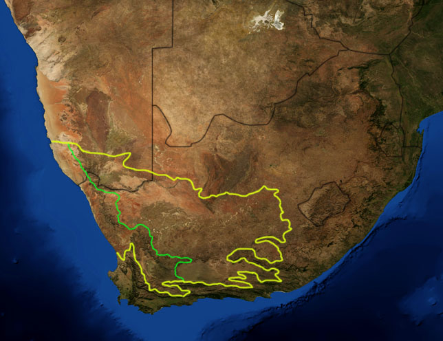
| Beskriiwang | This is a map showing the location of the two Karoo ecoregions of southern Africa, as delineated by the World Wide Fund for Nature. The yellow line encloses the two ecoregions. The green line separates the Succulent Karoo, on the west, from the Nama Karoo, on the east. National boundaries are shown in black. I, Pfly, made it using NASA Blue Marble imagery and ecoregion GIS data which I simplified and digitized in Photoshop. |
| Dootem | |
| Kwel | NASA, plus my additions by myself. |
| Skriiwer of Konstler | Pfly |
Lisens
| Diese Datei ist gemeinfrei (public domain), da sie von der NASA erstellt worden ist. Die NASA-Urheberrechtsrichtlinie besagt, dass „NASA-Material nicht durch Urheberrecht geschützt ist, wenn es nicht anders angegeben ist“. (NASA-Urheberrechtsrichtlinie-Seite oder JPL Image Use Policy). | ||
 |
Warnung:
|
Datei wersioonen
Klike üüb en tidjponkt, am detdiar wersion uuntulukin.
| Dootem/Tidj | Föörskaubil | Miaten | Brüker | Komentaar | |
|---|---|---|---|---|---|
| aktuel | 22:29, 19. Jan. 2007 | | 644 × 496 (114 KB) | Pfly | {{Information |Description=This is a map showing the location of the two Karoo ecoregions of southern Africa, as delineated by the World Wide Fund for Nature. The yellow line encloses the two ecoregions. Th |
Hü det datei brükt woort
Detdiar sidj brükt detdiar datei:
Globaal brük faan datein
Jodiar ööder Wikis brük detdiar datei:
- Brük üüb af.wikipedia.org
- Brük üüb bg.wikipedia.org
- Brük üüb ca.wikipedia.org
- Brük üüb de.wikipedia.org
- Brük üüb en.wikipedia.org
- Brük üüb eo.wikipedia.org
- Brük üüb es.wikipedia.org
- Brük üüb fi.wikipedia.org
- Brük üüb fr.wikipedia.org
- Brük üüb fr.wiktionary.org
- Brük üüb gl.wikipedia.org
- Brük üüb hu.wikipedia.org
- Brük üüb it.wikipedia.org
- Brük üüb ja.wikipedia.org
- Brük üüb ka.wikipedia.org
- Brük üüb ko.wikipedia.org
- Brük üüb lt.wikipedia.org
- Brük üüb nl.wikipedia.org
- Brük üüb no.wikipedia.org
- Brük üüb pt.wikipedia.org
- Brük üüb ru.wikipedia.org
- Brük üüb sv.wikipedia.org
- Brük üüb sw.wikipedia.org
- Brük üüb tr.wikipedia.org