Datei:Klimagürtel-der-erde-eisklima.png

Grate faan detdiar föörskaubil: 800 × 400 pixel. Ööder apliasangen: 320 × 160 pixel | 640 × 320 pixel | 1.024 × 512 pixel | 1.280 × 640 pixel | 3.600 × 1.800 pixel.
Originaal datei (3.600 × 1.800 pixels, dateigrate: 664 KB, MIME-typ: image/png)
Beskriiwang
| Beskriiwang |
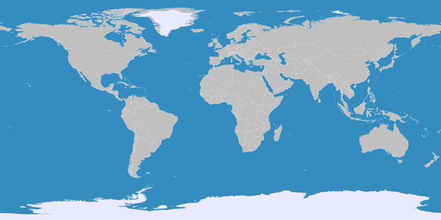
English: This map shows the Earth zones with an ice cap polar climate. Deutsch: Diese Karte stellt die polare Eisklimazone der Erde dar.
. |
| Dootem | |
| Kwel |
English: Own work on the basis of the following data: Deutsch: Selbst erstellt auf Basis dieser Geodaten:
|
| Skriiwer of Konstler | LordToran |
| Ferloof (Hü det datei brükt woort) |
boe |
| Ööder wersioonen |
 |
Lisens
Detdiar datei häält en lisens oner det Creative-Commons-lisens „Nööm nääm - Oner salew konditjuunen 3.0. Ei portiaret“.
- Dü mutst detdiar werk
- widjer du – detdiar werk kopiare an widjer du
- nei tuupstel – det werk feranre
- Oner jodiar konditjuunen:
- Nööm nääm – Dü skel di nööm faan di skriiwer of konstler nääm. Oober ei so, dat at so ütjsjocht, üs wan hi din werk gud fanjt.
- Oner josalew konditjuunen widjerdu – Wan dü detdiar werk feranerst, skel dü det resultaat oner detsalew lisens widjer du.
Datei wersioonen
Klike üüb en tidjponkt, am detdiar wersion uuntulukin.
| Dootem/Tidj | Föörskaubil | Miaten | Brüker | Komentaar | |
|---|---|---|---|---|---|
| aktuel | 23:05, 11. Okt. 2016 | | 3.600 × 1.800 (664 KB) | Maphobbyist | The Caspian Sea was omitted. The Köppen system is based on the concept that climate types are correlated with the natural vegetation. |
| 17:12, 15. Okt. 2007 |  | 3.600 × 1.800 (562 KB) | Lortordermur | ||
| 22:41, 5. Jun. 2007 |  | 3.445 × 1.731 (603 KB) | Lortordermur | == Beschreibung == {{Information |Description=Diese Karte stellt die polare Eisklimazone der Erde dar. |Source=Selbst erstellt auf Basis [http://www.copernicus.org/EGU/hess/hessd/4/439/hessd-4-439.htm dieser Karte], welche unter einer Creative-Commons-Li |
Hü det datei brükt woort
Detdiar sidj brükt detdiar datei:
Globaal brük faan datein
Jodiar ööder Wikis brük detdiar datei:
- Brük üüb be.wikipedia.org
- Brük üüb fa.wikipedia.org
- Brük üüb nl.wikipedia.org