Datei:Map of Chester County Pennsylvania With Municipal and Township Labels.png
Diar as nian huuger apliasang diar.
Map_of_Chester_County_Pennsylvania_With_Municipal_and_Township_Labels.png (637 × 566 pixels, dateigrate: 80 KB, MIME-typ: image/png)

|
File:Map of Chester County Pennsylvania With Municipal and Township Labels.svg ist eine vektorisierte Version dieses Bildes. Diese sollte an Stelle des Rasterbildes verwendet werden, sofern sie nicht schlechter ist.
File:Map of Chester County Pennsylvania With Municipal and Township Labels.png → File:Map of Chester County Pennsylvania With Municipal and Township Labels.svg
Für weitere Informationen siehe Help:SVG. |
 |
Beskriiwang
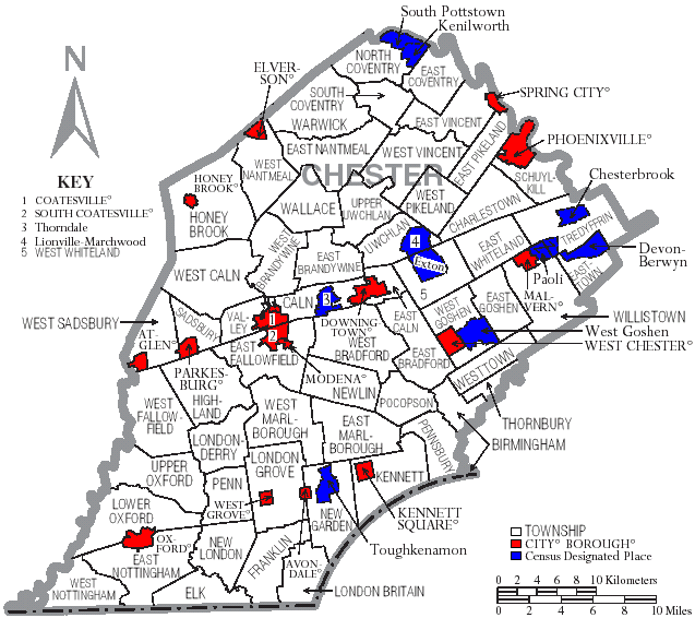
| Beskriiwang | Map of Chester County, Pennsylvania, United States with township and municipal boundaries |
| Dootem | |
| Kwel | taken from US Census website [1] and modified by User:Ruhrfisch |
| Skriiwer of Konstler | US Census, Ruhrfisch |
| Ferloof (Hü det datei brükt woort) |
US Census / US Government work is public domain, my modifications licensed under the GNU Free Documentation License |
Lisens

|
Dü könst det datei kopiare, widjerdu of feranre efter a reegeln faan't GNU Free Documentation License, wersion 1.2 of leeder faan't Free Software Foundation; diar as niks ünferanerlik an nään tekst üüb a föör- of bääftsidj. Dü könst di lisens tekst efterlees bi GNU Free Documentation License. |
| Detdiar datei häält en lisens oner det Creative-Commons-lisens „Nööm nääm - Oner salew konditjuunen 3.0. Ei portiaret“. | ||
| ||
| Detdiar lisenstiaken kaam mä't GFDL lisens update. |
Datei wersioonen
Klike üüb en tidjponkt, am detdiar wersion uuntulukin.
| Dootem/Tidj | Föörskaubil | Miaten | Brüker | Komentaar | |
|---|---|---|---|---|---|
| aktuel | 17:02, 13. Sep. 2008 | | 637 × 566 (80 KB) | Ruhrfisch | Cleanup, all other information the same |
| 22:54, 18. Apr. 2006 |  | 637 × 566 (82 KB) | Ruhrfisch | {{Information| |Description= Map of Chester County, Pennsylvania, United States with township and municipal boundaries |Source= taken from US Census website [http://www2.census.gov/geo/maps/general_ref/cousub_outline/cen2k_pgsz/pa_cosub.pdf] and modified |
Hü det datei brükt woort
Detdiar sidj brükt detdiar datei:
Globaal brük faan datein
Jodiar ööder Wikis brük detdiar datei:
- Brük üüb de.wikipedia.org
- Brük üüb en.wikipedia.org
- Brük üüb eo.wikipedia.org
- Brük üüb es.wikipedia.org
- Brük üüb it.wikipedia.org
- Brük üüb ja.wikipedia.org
- Brük üüb kw.wikipedia.org
- Brük üüb nl.wikipedia.org
- Brük üüb pl.wikipedia.org
- Brük üüb pt.wikipedia.org